Magnetic Field Imaging & Detection System
Real-time visualization of underground magnetic anomalies
What is Magnetron Geoscan?
Magnetron Geoscan is an advanced magnetic field imaging system designed to detect and visualize underground anomalies in real-time.
By combining high-sensitivity sensors with powerful data processing software, the system transforms invisible magnetic signals into clear visual maps.
PRODUCTS
MAGNETRON CORE
Next-Generation Portable Magnetic Field Scanning System
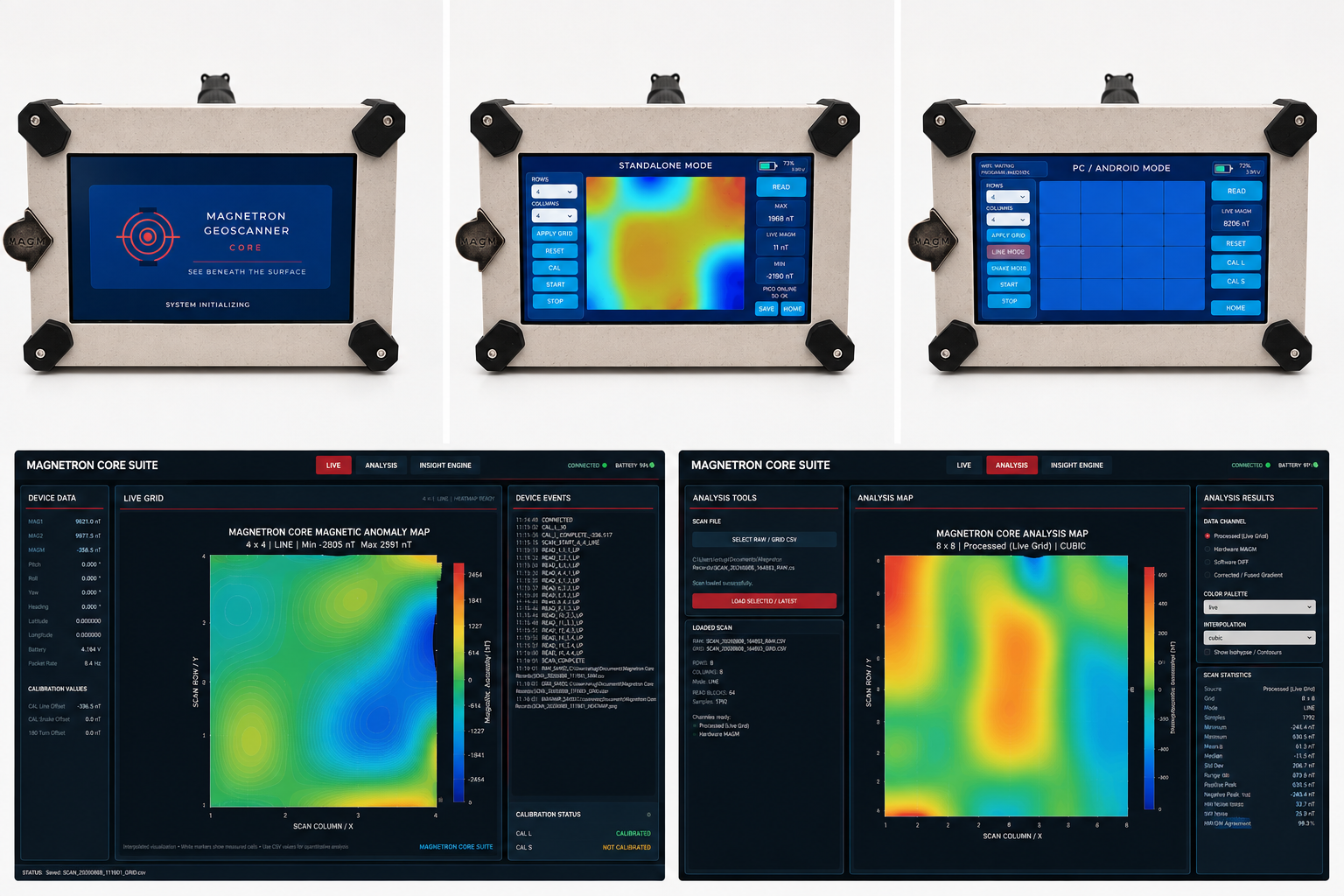
Magnetron Core is a new-generation portable magnetic field scanning platform developed for high-resolution detection, mapping and visualization of magnetic anomalies.
The system combines a dual fluxgate sensor architecture, high-resolution 32-bit data acquisition, dedicated real-time processing hardware and a large 7-inch touchscreen interface in a fully portable field unit.
Unlike conventional systems that require an external computer during measurement, Magnetron Core can operate completely independently in Standalone Mode. The operator can define the scanning grid, calibrate the system, monitor live magnetic values, collect measurements and generate a color magnetic anomaly map directly on the device.
For more advanced surveys, PC / Android Mode enables wireless communication with external software while the Core continues to operate as the field acquisition platform.
The system supports multiple grid configurations and LINE / SNAKE scanning methods, while integrated orientation sensing helps maintain consistent measurement geometry during field operation. Scan data can also be stored for later processing and detailed analysis.
Magnetron Core was designed as a complete field platform rather than simply a magnetic sensor reader — bringing data acquisition, calibration, visualization, mapping and external connectivity into a single portable system.
Dual fluxgate magnetic sensing • 32-bit high-resolution ADC • 7" touchscreen HMI • Standalone field operation • Real-time magnetic anomaly mapping • Adjustable scan grids • LINE / SNAKE scanning • Integrated orientation sensing • Local data storage • Wireless PC / Android connectivity • Portable battery-powered architecture
MAGNETRON CORE SUITE
From Magnetic Measurements to Advanced Field Interpretation
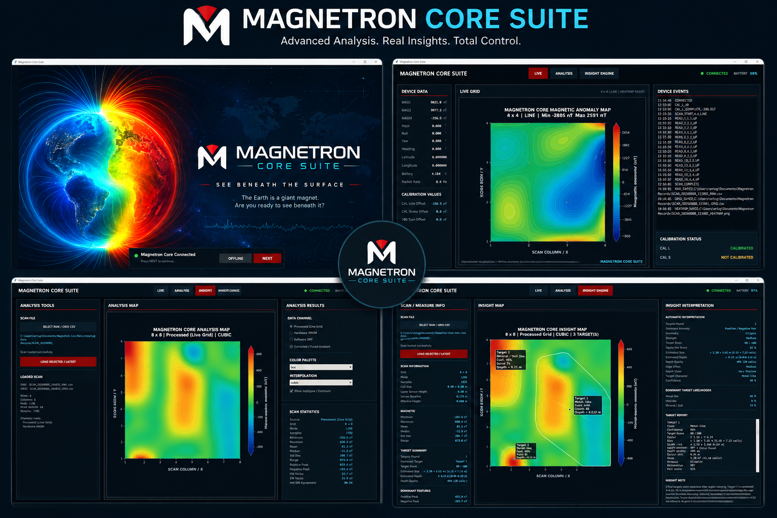
Magnetron Core Suite is the dedicated analysis and visualization environment developed specifically for the Magnetron Core platform.
The software communicates wirelessly with the Core device and transforms field measurements into detailed magnetic anomaly maps while providing real-time access to sensor values, orientation information, calibration parameters, battery status and acquisition events.
The LIVE workspace provides real-time survey control and visualization. Measurements collected across the scan grid are processed into an interpolated magnetic map, allowing anomalies to become visible while the survey is still in progress.
The ANALYSIS workspace provides deeper examination of recorded surveys. Multiple data channels, interpolation methods, contour visualization and statistical tools allow the operator to evaluate both raw and processed magnetic information and compare characteristics of detected anomalies.
The INSIGHT ENGINE adds an automated interpretation layer to the platform. It analyzes the spatial and magnetic characteristics of detected anomaly regions and provides information such as target regions, anomaly strength, geometry, positive/negative magnetic relationships, estimated dimensions and other interpretation parameters.
Rather than replacing operator judgment, Insight Engine is designed to provide an additional analytical perspective and help identify areas that may deserve closer investigation.
Together, Magnetron Core and Core Suite create a unified workflow:
SCAN → MAP → ANALYZE → INTERPRET
From field acquisition to detailed post-processing, the entire workflow remains within the Magnetron Core ecosystem.
Core Suite Features: Wireless Core connection • Real-time LIVE mapping • Magnetic anomaly visualization • RAW and processed data analysis • Multiple interpolation methods • Contour / isohypse visualization • Scan statistics • Calibration monitoring • Automatic anomaly region detection • Target characterization • Estimated anomaly dimensions • Insight Engine assisted interpretation • Survey recording and post-analysis
BASIC model V2
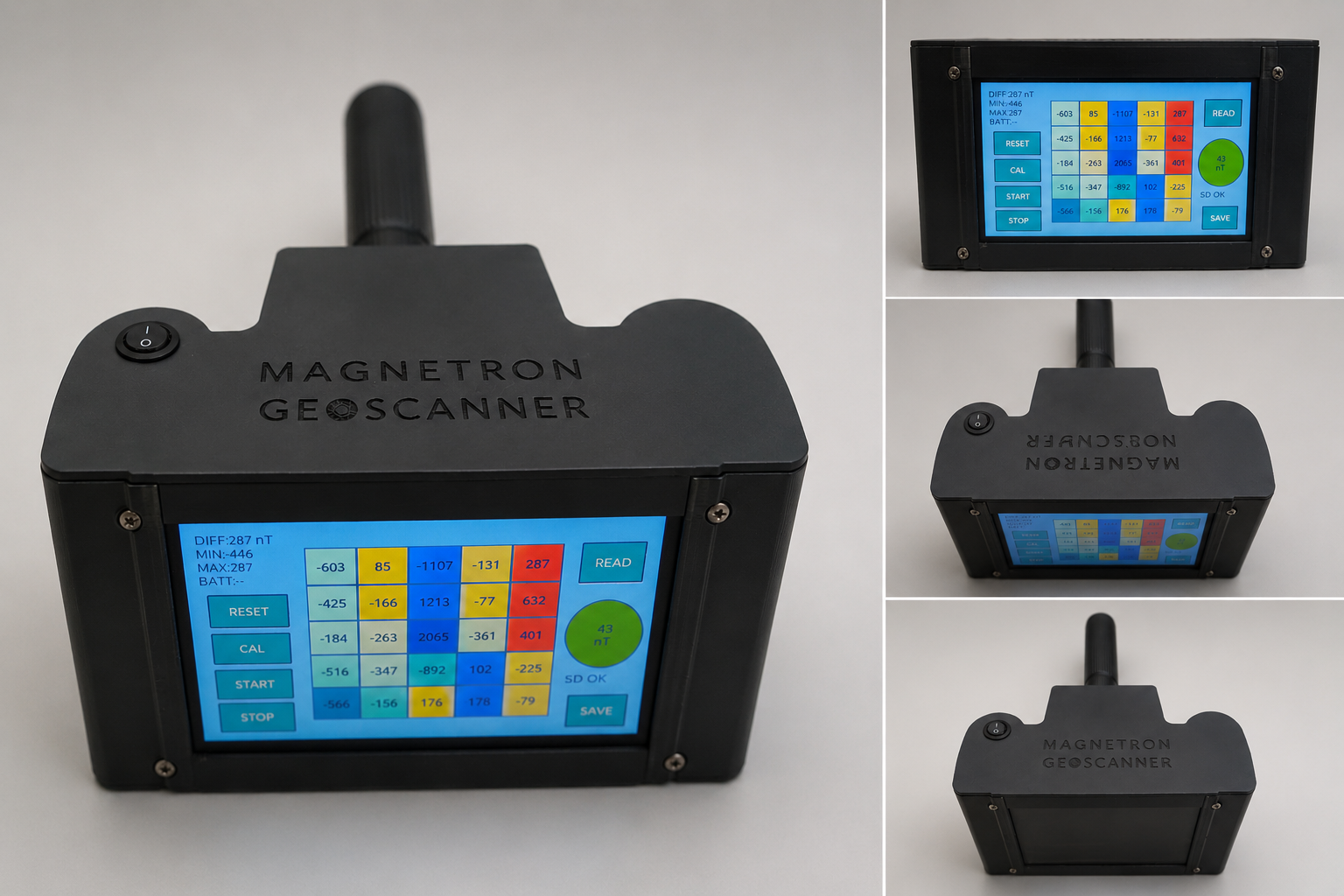
Entry-level magnetic field imaging system designed for fast preliminary field scanning and anomaly detection.
The Basic model uses dual EMS100 or FLC100 fluxgate sensors with a compact short sensor tube design. Measurements are collected using a manual 5x5 grid scanning method and processed into standalone heatmap visualizations directly on the device. Scan data can also be saved to SD card storage for later analysis.
Powered by an ESP32-S HMI system with a built-in display interface, the device offers a lightweight and portable solution for field operations. A Nano ADC architecture provides 10-bit resolution for magnetic signal acquisition, while the dual 18650 (2S) battery system ensures fully portable standalone operation.
• Dual EMS100 / FLC100 sensor support
• Manual 5x5 grid scanning system
• Standalone heatmap generation
• Optional SD card data recording
• Compact short sensor tube design
• Nano ADC – 10-bit resolution
• ESP32-S HMI interface
• Portable 2S 18650 battery system
Ideal for:
Preliminary surveys, educational use, rapid field scanning, and lightweight portable operations.
The MAGNETRON GEOSCANNER BASIC project files, firmware, STL package, and documentation are available on Cults3D:
https://cults3d.com/@edosari
STANDARD MODEL
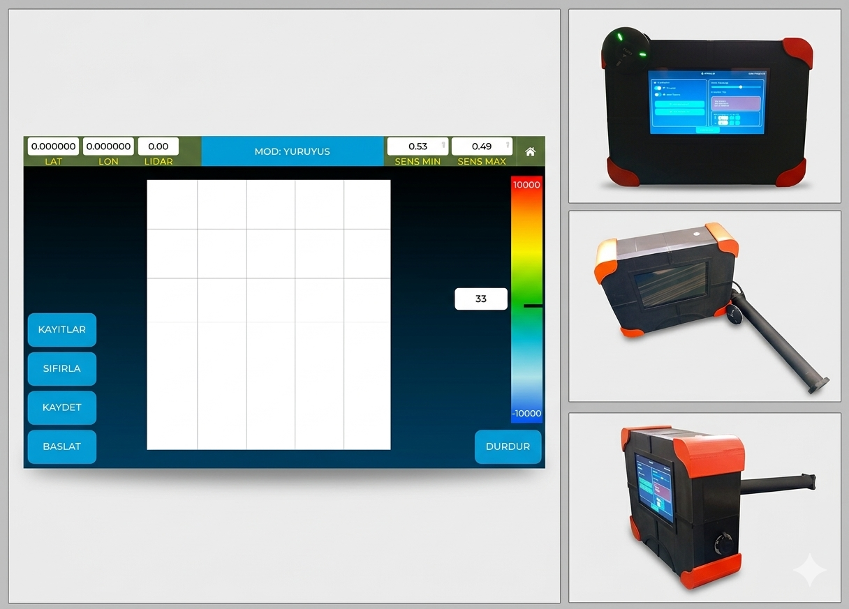
Advanced standalone magnetic field imaging system designed for real-time field scanning, underground anomaly visualization, and synchronized PC-based analysis.
The Standard model features dual EMS100 or FLC100 fluxgate sensors mounted on an extended sensor tube for improved sensor separation and enhanced deep-target response. Sensor signals are filtered through an LC filtering stage before being processed by a high-resolution 32-bit ADC system. Primary preprocessing operations are handled by the RP2040 processor before sensor, GPS, IMU, and LiDAR data are combined into a unified scanning pipeline.
The system integrates a NEO-3 series GPS module, BNO055 IMU sensor, and a 15-meter TF Mini LiDAR sensor to support position tracking, motion analysis, orientation correction, and distance-aware scanning. All processed data is visualized in real-time on the integrated 7-inch ESP32 touchscreen HMI.
The Standard model supports two operating modes:
Walking Mode
When GPS signal is available, the system connects wirelessly to the PC software via WiFi socket communication. During operation, real-time magnetic heatmaps are generated live while walking. The software performs scan synchronization, path correction based on walking speed and step movement, data recording, and advanced visualization analysis.
Standalone Grid Scan Mode
In standalone operation, the user selects a scan area directly from the touchscreen interface, from 2x2 meters up to 20x20 meters. The operator then performs a slow step-by-step scan using movement detection and synchronized grid mapping. The system creates standalone magnetic maps and heatmap visualizations directly on the device without requiring GPS connectivity.
• Dual EMS100 / FLC100 sensor architecture
• Extended sensor tube for improved deep-target response
• LC filtered sensor input stage
• 32-bit high-resolution ADC system
• RP2040 preprocessing engine
• Integrated NEO-3 GPS module
• BNO055 IMU integration
• 15m TF Mini LiDAR support
• 7-inch ESP32 touchscreen HMI
• WiFi PC synchronization support
• Real-time heatmap generation
• Standalone grid mapping mode
• Scan area selection from 2x2m to 20x20m
Ideal for:
Advanced underground scanning, field surveys, real-time magnetic mapping, and portable geophysical analysis operations.
ADVANCED MODEL
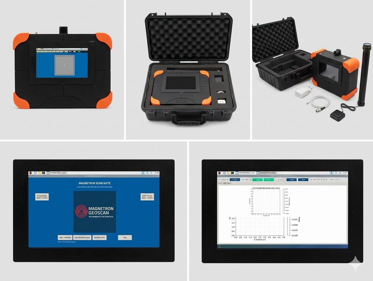
High-resolution all-in-one magnetic imaging and underground analysis platform designed for advanced field operations, synchronized scanning, and integrated onboard processing.
The Advanced model uses dual fluxgate magnetic sensors combined with filtered 32-bit ADC acquisition hardware for highly detailed magnetic anomaly measurements. Sensor preprocessing operations are handled by the Pico 2 RP2040 subsystem before data is transferred to the main Raspberry Pi 5 processing unit.
This model integrates an industrial-grade BNO085 IMU sensor, high-precision 50-meter Benewake LiDAR, and a Waveshare high-accuracy GPS module with optional RTK capability for improved positioning performance and motion tracking accuracy.
Unlike the Standard model, the Advanced system operates as a complete SBC-based embedded scanning platform. All scanning, visualization, recording, analysis, and processing software runs directly on the integrated Raspberry Pi 5 system with a dedicated embedded operating environment and 7-inch touchscreen interface.
The device supports multiple operating modes, including:
Real-time walking scan mode
Standalone fixed-area grid scanning
Vertical directional scanning mode for forward-facing analysis while stationary
Both processed scan data and raw magnetic telemetry can be recorded during operation. After scanning, the onboard software allows detailed heatmap analysis and advanced visualization directly on the device.
The system also includes a dedicated depth estimation analysis application integrated into the software suite for additional underground interpretation workflows.
For extended operation and external processing, the Raspberry Pi system can synchronize wirelessly with a PC over WiFi for live data sharing and remote analysis support.
• Dual fluxgate magnetic sensor architecture
• LC filtered sensor acquisition stage
• 32-bit high-resolution ADC system
• Pico 2 RP2040 preprocessing engine
• Raspberry Pi 5 main processing platform
• Industrial-grade BNO085 IMU
• 50m Benewake precision LiDAR
• Waveshare high-accuracy GPS with RTK support
• Embedded Linux-based software environment
• Integrated 7-inch touchscreen interface
• Real-time magnetic heatmap visualization
• Raw telemetry recording support
• Advanced onboard analysis tools
• Integrated depth estimation software
• Vertical directional scanning mode
• WiFi synchronization with PC software
• All-in-one SBC field operation platform
Ideal for:
High-resolution underground magnetic imaging, advanced field surveying, synchronized data acquisition, onboard analysis workflows, and portable geophysical research operations.
MAGNETRON SCAN SUITE
MAGNETRON Scan Suite is an integrated magnetic field visualization and analysis platform developed for field scanning, anomaly mapping, and post-processing analysis.The system combines real-time data acquisition, live heatmap generation, advanced visualization tools, and multi-stage analysis workflows into a single environment.The software is designed to work with both Walking Scan Mode and Static Scan Mode, while also including a dedicated Depth Analysis Module for advanced interpretation.
Main Launcher Interface
The software starts from a central launcher interface where the operator can select:
Walking Mode (Scan + Analysis)
Static Scan Mode (Scan + Analysis)
Depth Analysis
This structure allows fast switching between field operation and advanced analysis workflows.
Walking Scan Mode
In Walking Mode, the system operates with GPS-assisted live scanning.As the operator walks through the survey area, the software continuously generates a real-time magnetic heatmap on the screen.
Collected data can be saved automatically as:
Raw scan data
PNG heatmap images
Google Earth compatible KML files
The generated KML files allow scan results to be visualized directly on geographic maps.
Walking Mode Analysis
After scanning, the built-in analysis window can be opened directly from the main interface.Users can select saved scan files and apply multiple processing options such as:
Interpolation methods
Color palette selection
Line correction
Averaging and smoothing
Grid refinement
Contour generation
Heatmap enhancement
The processed results can then be:
Rotated Mirrored Re-oriented
Exported again as KML overlays for Google Earth
The system also supports:
3D surface visualization - Contour / isoline mapping - Enhanced color smoothing - Advanced heatmap rendering
Static Scan Mode
Static Scan Mode is designed for controlled area scanning while the operator remains in a fixed scanning position. Before scanning begins:
The IMU is calibrated - The scan region is initialized
During scanning, the operator slowly sweeps the target area while the software builds a live scan box and continuously updates the magnetic response.
When scanning stops:
A magnetic heatmap is generated automatically - Scan data is saved for later analysis - Static Mode Analysis
The Static Analysis window includes advanced visualization features such as:
3D visualization - Contour / isohypse generation - Color smoothing - Interpolation controls
Advanced rendering adjustments
This allows detailed inspection of anomaly structure and signal distribution.
Depth Analysis Module
The Depth Analysis module is designed for advanced interpretation of recorded raw magnetic data.
The operator selects: The source scan mode - The raw data file
After analysis begins, the software generates multiple depth estimation and anomaly interpretation maps using different analytical approaches.
Available analysis outputs include:
Residual Magnetic Anomaly - SPI (Source Parameter Imaging) - Euler Solutions - Analytic Signal Amplitude - Vertical Derivative Maps - Smoothed Total Magnetic Field Maps
The software produces approximately six different interpretive visualization layers to help estimate anomaly structure and possible depth behavior.
Integrated All-In-One Architecture The complete system is designed as an integrated all-in-one field platform combining:
Real-time acquisition
Visualization
Heatmap generation
Geographic export
Advanced analysis
Depth interpretation
within a unified workflow.
The platform supports both standalone operation and synchronized external analysis workflows when connected through Wi-Fi or local network environments.
